|
|
|
|
|
|
| |
| |
By Category |
 |
|
|
| |
|
| |
| |
India On Media |
|
|
|
| |
|
| |
|
|
| Politics
News |
|
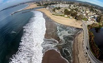
| 'Citizen Scientists' Use Drones |
| 'Citizen Scientists' Use Drones To Map El Nino Flooding In California
|
| UNITED STATES OF AMERICA
, 27-January-2016
8:26:10 AM |
| Forget about selfies. In California, residents are using smartphones and drones to document the coastline's changing face.
Starting this month, The Nature Conservancy is asking tech junkies to capture the flooding and coastal erosion that come with El Nino, a weather pattern that's bringing California its wettest winter in years - and all in the name of science.
The idea is that crowd-sourced, geotagged images of storm surges and flooded beaches will give scientists a brief window into what the future holds as sea levels rise from global warming, a sort of a crystal ball for climate change.
Images from the latest drones, which can produce high-resolution 3D maps, will be particularly useful and will help scientists determine if predictive models about coastal flooding are accurate, said Matt Merrifield, the organization's chief technology officer.
"We use these projected models and they don't quite look right, but we're lacking any empirical evidence," he said. "This is essentially a way of 'ground truthing' those models."
Experts on climate change agreed that El Nino-fueled storms offer a sneak peak of the future and said the project was a novel way to raise public awareness. Because of its crowd-sourced nature, however, they cautioned the experiment might not yield all the results organizers hoped for, although any additional information is useful.
|
|
|
|
|
|
|
|
ADVERTISEMENTS
Free offer!!! Become an administrator for your zip home page, "Post" local news (local to your postcode)& pictures, "Post" advertisement banners from local companies. Make Extra money.
|
 |
 |
|
|
| |
|